Long-term signal vs. Short-term noise


Insight
How can satellites help to combat rising global pesticide usage?
Satellites are now essential for everything from global communication networks to military logistics, but it’s their newfound application in precision agriculture that’s providing unheralded economic and environmental benefits.
While space-age technology is normally the domain of NASA scientists and Silicon Valley researchers, a young Australian farmer is blazing his own trail by leveraging this technology to improve the health and prosperity of Australia’s crops.
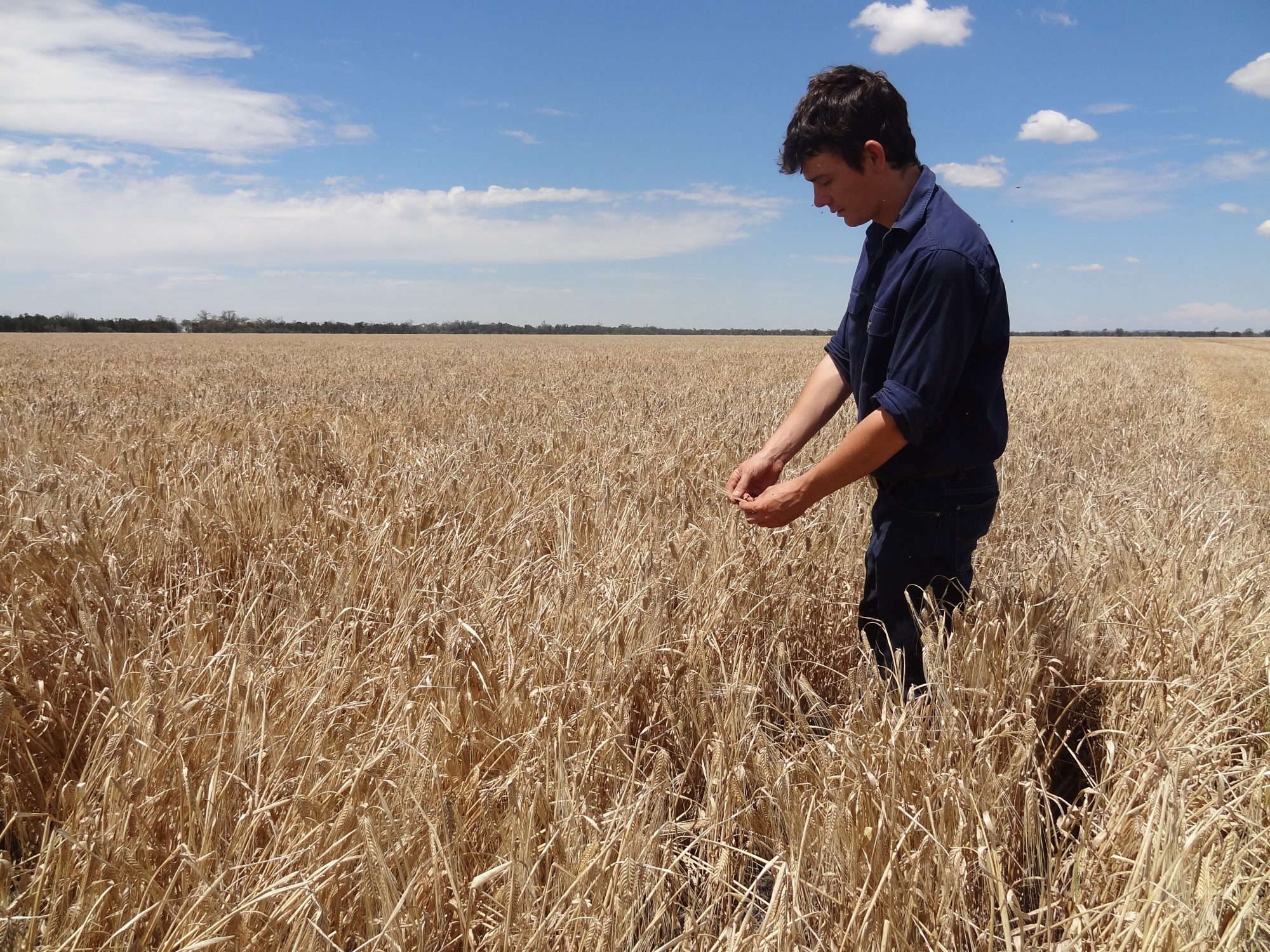
Ben Boughton has created a successful business called Satamap which uses satellite imagery from US and European authorities to provide a bird’s eye view of the Australian countryside.
By providing agronomists and farm advisors with customised satellite imagery over a range of dates, farmers are able to compare these images to see how the vegetation has changed over time, allowing them to make smarter use of pesticides.
Boughton’s family farms wheat, barley and chickpeas near Moree in Northern NSW and it was during his agricultural science studies at university that he first recognised the opportunity that satellite technology presented.
“There was a precision agriculture subject which interested me and I approached a guest lecturer to do some work experience for their consulting firm where I was exposed to high-accuracy GPS for rapid land surveying, satellite imagery and yield mapping,” Boughton says. “I also had a keen interest in computers so the two met up nicely.”
Boughton had begun creating his own unmanned aerial vehicles (UAVs), or drones, which he says was partly for fun but also to explore new ways of collecting accurate spatial data to allow better land management decisions.
After being awarded a Nuffield Scholarship in 2014, Boughton travelled the world to research drone technology in precision agriculture, learning enough about the growing use of satellite imagery to get Satamap up and running.
“Satamap is about Australian agribusiness getting the information it needs now without waiting on technology to trickle down from Silicon Valley,” Boughton says.
“Its design and success is due to its simple operation and the feedback from agronomists and farmers being fed straight back to our developers.”
Pesticides are an essential tool for ensuring the commercial viability of many of Australia’s crops.
In fact, an estimated 68% of Australia’s food crops can be directly attributed to the use of pesticides. The problem with pesticides is they present significant risks for human health as well as the problem with pesticides is they present significant risks for human health as well as the environment.
Australia also has widespread problems with weed resistance – which is where solutions such as those offered by Satamap can provide long term benefits.
“If herbicides are used and weeds survive, this is how resistance develops, so the satellite imagery allows us to monitor the effectiveness of the herbicides we’re using,” Boughton explains.
“Farmers are then able to locate weed escapes and eradicate these small areas of resistant weeds mechanically so they don’t seed and build up the resistant population. This also reduces the amount of chemical required in subsequent years.”
While the safe use of pesticides is heavily regulated in countries like Australia and the US, UN research reveals the estimated costs of poisonings from pesticides in sub-Saharan Africa now exceeds the total annual international aid given to the region for basic health services.
In developing countries, it’s often cheaper to import highly hazardous pesticides despite the availability of safer alternatives. This is then compounded by a general lack of education about safe spraying practices.
If these farmers were provided with the same satellite imagery as their Australian counterparts, they would be armed with the knowledge they need to combat the growing health problems they face in trying to feed growing populations with limited resources.
As the costs of launching and communicating with satellites has been drastically lowered in recent years, the timing is ideal for farmers all over the globe to begin using satellite imagery to better guide their land management decision making.
The first satellite launched into Earth’s orbit was a 58cm ball of polished steel called Sputnik.
Launched by Russia in 1957, Sputnik’s four antennas transmitted signals back to Earth for about three weeks before its battery died. While Sputnik provided scientists with valuable information such as the density of the upper atmosphere, its real success was in simply getting the jump on the US in the dawn of the space age.
Nearly 60 years later, there are an estimated 1400 satellites hurtling across the sky above us.
Over the next five years that number is expected to increase by up to 40% as several commercial agencies begin launching smaller and more cost-effective satellites into orbit.
Planet Labs is a start-up created by a group of ex-NASA researchers who decided launching satellites didn’t need to cost millions of dollars.
After coming to the conclusion that modern smartphones possessed more computing power than most of the satellites in the atmosphere, the team at Planet Labs decided to launch three modified Google Nexus 1 phones into space at a total cost of $3500.
While the experiment proved successful, with the phones transmitting signals back to earth along with some very low-resolution imagery, the technology in Planet Labs’ satellites is now of a much higher standard.
Planet Labs will have around 100 satellites in orbit by the end of 2016, all of which will be quietly snapping away a medium-resolution image of every square inch of the planet.
This would constitute the largest private collection of satellites and is a sign of the rapid democratisation of space technology that is currently under way.
As this storm of images begins to rain down from space, the new challenge will be finding ways to make sense of such a large volume of information.
That’s why Boughton believes there are still significant improvements to be made in the way imagery is presented to decision makers.
“The farmer and agronomist brains will almost always be required when a management decision needs to be made but one challenge is the potential for information overload when we’re at the point of the whole earth captured every day by satellite and countless other sensors,” he says.
While Satamap helps farmers to lift business performance, they also enable farmers to slash their energy use and the environmental impacts of chemical usage on their land.
Innovative agricultural businesses like Satamap are drawing much needed attention to the potential application of technology in solving some of Australian agriculture’s sustainability issues while also opening up new opportunities for sustainable investment programs.
One such program is NAB’s partnership with the Clean Energy Finance Corporation (CEFC) which has seen more than $120 million of investment in technology that helps farmers to cut their energy and operating costs.
While precision agriculture programs like Satamap are part of the overall solution for unlocking environmental improvements in Australian agriculture, the investment program from NAB and the CEFC also encompasses large on-farm clean energy projects such as solar, wind and biogas.
In the growing field of satellite technology in precision agriculture, it seems we’ve only begun to scratch the surface of new possibilities as the information beamed down from these manmade heavenly bodies becomes more available and affordable.
The sky is definitely the limit in terms of the application of this technology for allowing farmers to grow healthier and more sustainable food crops for the long term.

Long-term signal vs. Short-term noise
Insight

Welcome to NAB’s newsletter on the Sustainable Finance market from an Australasian perspective.

Insight
© National Australia Bank Limited. ABN 12 004 044 937 AFSL and Australian Credit Licence 230686.