The NAB Rural Commodities Index climbed in April – increasing by 2.7% month-on-month in Australian dollar (AUD) terms.

Article
Farmers are using drones to collect information on everything from germination patterns to hail damage. Peter Birch, who operates a drone for farmers around Australia, discusses their value and the role they’re likely to play in the future.
When Peter Birch gets an invitation to a barbecue he’s usually asked to bring his drone.
“People find drones fascinating and they’re keen for a demonstration,” says Birch, an agronomist and Managing Director of B&W Rural, a rural merchandising business in Moree, New South Wales.
Drones can provide farmers with a very practical and cost-effective way of increasing both their yields and their profits.
For example, drones can be used to:
“They can certainly help growers make more informed decisions,” says Birch. “The question is should you invest in your own drone or would you be better off renting services as you need them?”
Birch and Brad Donald, a fellow agronomist at B&W Rural, operate drones for farmers around Australia. They charge about $3 a hectare for a complete service, including processing the information they collect – and, for many farmers, this is the more cost-effective and efficient option.
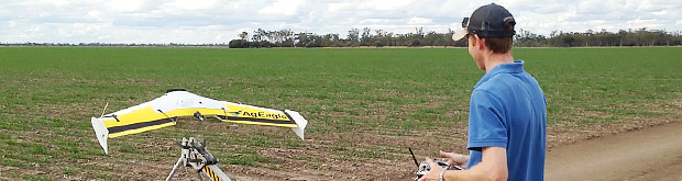
“The price of drones is continuing to fall and a sophisticated quadcopter can be purchased for about $1800,” says Birch. ”However, precise data requires more sophisticated – and expensive – technology. Our AgEagle cost close to $26,000 and other drones retail for up to $80,000.”
The AgEagle is a flying wing design fitted with a near infrared (NIR) camera.
“This captures so much detail we can count individual plants, even when they’re very small,” Birch continues. “This is particularly helpful for cotton farmers because some of the new high-yielding varieties can have establishment problems. Now, instead of spending hours walking the paddock trying to decide whether or not to re-sow, they can call us in and get an accurate percentage of plants that are growing and a clear picture of where they’re thin on the ground.”
The NIR camera produces around 600 images in a 150-hectare field and these are analysed with sophisticated computer technology.
“This is a complex and time-consuming process – it takes about 100 minutes to process the information collected on each of our AgEagle’s 30-35 minute flights – so most farmers employ someone to do the job for them,” says Birch.
There is also the matter of legal compliance.
“We’re in the process of gaining an Air Operator’s Certificate from the Civil Aviation Safety Authority,” Birch continues. “Anyone who flies a drone needs the time to understand and comply with the aeronautical rules.”
As drones continue to evolve it’s likely they will play an increasingly important role in helping farmers boost their productivity. Many farmers will turn to specialists to help them make the most of the technology – but they may still want a drone of their own.
“I can imagine a time when most farmers will have a new-generation quadcopter they use occasionally for the business and the rest of the time as a hobby,” says Birch.
More from NAB:

The NAB Rural Commodities Index climbed in April – increasing by 2.7% month-on-month in Australian dollar (AUD) terms.
Article


Download the 2025 NAB Regional and Agribusiness Horizons Report: Embracing Opportunity for data-led insights on the state of play in regional and rural Australia and the economic outlook for the remainder of 2025.

Report
© National Australia Bank Limited. ABN 12 004 044 937 AFSL and Australian Credit Licence 230686.